More on that guided busway
More on the guided busway, as it paves over the Bristol Harbour Railway and replaces most of Cumberland Road
As promised yesterday, I’ve been doing some closer looking at the West Of England Partnership’s guided busway – sorry, I mean “Bus Rapid Transit” plans, and some measuring up on aerial photos. It seems I made a couple of misconceptions, though. Firstly: some of the plans show the Harbour Railway converted into a sort of tramway running along the same road as the buses. Secondly, I was slightly wrong about the route in the Winterstoke Road area. My mistake was to assume that it might actually serve a residential area; I was wrong, it doesn’t, and its sole use is as a replacement for the current park-and-ride services. The council have also said it will serve the football ground; but that slightly contradicts other things they’ve said.
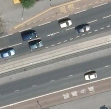
Anyway, here we go: what does a guided busway actually look like? Never mind the Partnership’s shiny traffic-free plan: here’s a real one. This is the A64 on the outskirts of Leeds, which has a single-carriageway busway down its central reservation.

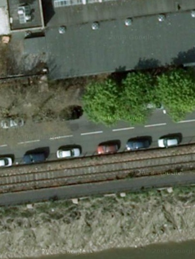
Never mind the bus lanes at top and bottom; the busway is that lovely expanse of concrete in the middle. The width of the whole thing, by my calculations,* comes out at about 3.8m. So, for a two-way busway such as the council wants to build in Bristol, you’re looking at 8m width. That’s for plain road without stops. Here’s a picture of where the council wants to build it: Cumberland Road. To the same scale, as you can tell by the cars.

From the top: road, railway, cycle track, river.
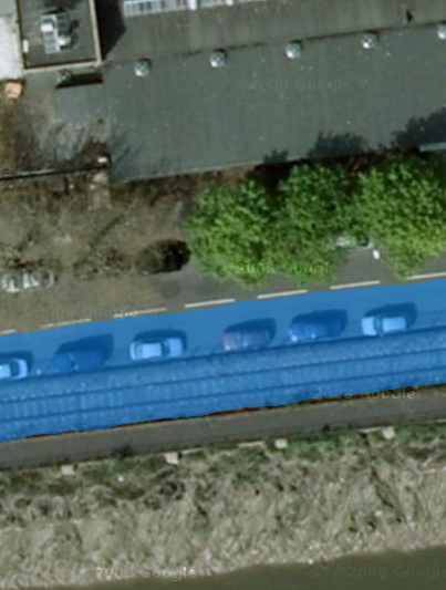
The plans include building over the railway for one side of the bus route. Remember what Councillor Bradshaw told me: the plans “do not prevent” trains being run. Does that mean no bus services at weekends when the railway’s running? Or fewer trains? Who, at present, knows? Anyway, that means, for our Militant Invective Laboratories simulation (better value that the Partnership’s, I’m sure), we only need paint over part of the road:

There goes the railway and just under 4m of the road, painted over in wobbly freehand. That’s the amount of land the council’s planning to concrete over for its posh new buses (and all the older ones which will also be allowed to use the busway).
So, goodbye to half of Cumberland Road – even by narrowing the pavement on the north side, there wouldn’t be enough room to make the road full-width. The council’s simulation does seem to show there being a bus lane in the road at this point, rather than a proper busway. However, there’s a slight problem with that: the buses and the road traffic would be going in opposite directions, unless one were to drive on the right, so no space gets saved. The published proposals go on and muddy this point by showing both buses and normal traffic driving on the right at this point – which, of course, would be no help at all.
Still to come: the even more awkward pinch-point where the busway is due to run alongside the Portbury Dock railway line, at Winterstoke Road, with a stop which will take up even more space. They seem to be planning to run the busway over Network Rail land – I wondered if Network Rail knew about that, so I’ve asked them. For that matter, I wonder who owns the land the rest of the busway will run on – presumably either Network Rail or BRB Residuary, the organisation that is one of the last remaining stubs of British Rail. BRBR’s website is a bit broken at the moment, so I can’t search their property listings to see what they do or don’t own.
* including the small width of kerb separating bus and road on the buses’ left, which is presumably needed for safety reasons.

 Home
Home