Guided Bus
In which we discuss the West Of England Partnership’s misguided bus proposals
Through my door the other day: a leaflet from the West Of England Partnership, the organisation made up of local councils* that replaced the dead and unlamented Avon County Council. It’s about their proposals for a guided busway scheme in this part of the city. A new road, in other words, limited to buses only. Some of the buses on it would be expensive new buses cunningly disguised to look like trams, and running on “sustainable fuel”;** the rest would be the boring ordinary diesel ones that already serve this area. It would replace the current park-and-ride buses in this area, which are already the nicest and most modern buses in this part of the city. So, frankly, I don’t see why that’s the bus route that most urgently needs replacing.*** You can see their proposals for yourself, on the Partnership’s website – they very carefully avoid using the term “guided busway”, and instead call it “rapid transit”, using the word “bus” as little as possible.
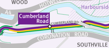
The route isn’t really any more useful than the current park-and-ride scheme, either. It’s going to be built along the old railway line that served Bristol Harbour. A small part of this is disused; some is still used by trains to the docks that are still open, but most is used by the Bristol Harbour Railway, a council-owned steam railway that chugs up and down the Avon and the Harbourside, and does a pretty good trade. Here’s an extract from the map on the website:

The purple line there is the new bus route, and the yellow line is the railway. The black blob there, looking like a station, is a proposed Cumberland Road bus stop – handy for Southville, because there’s a footbridge across the river there. The green line is a cycle path.
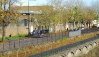
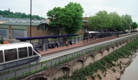
Now, so far, this is just a line on a map. Not much detail design work seems to have been done – one of the councillors responsible, Mark Bradshaw, said as much to the local paper with the words: “Residents, businesses and other stakeholders are invited to engage in this work and help shape the detail of the proposals.” However, the Partnership have gone as far as producing a mockup of the proposed Cumberland Road bus stop. Here’s their design. On the right: the new bus stop. On the left: a photo I took a few days ago from almost the same location, although I didn’t quite get the angle right.


You can see, on my “present day” photo, the railway line – it’s behind the yellow fence and in front of the road, and you can make out the rails if you look carefully. More interestingly, you can see that on the Partnership’s artist’s impression, the railway isn’t there any more. The cycle path along the riverbank is still there; but the railway line on the other side of it has been paved over and turned into busway. So, in fact, has half of the road on the other side – you can see, the busway near the platform comes out almost as far as the centre-line of the road.
Mark Bradshaw is, as it happens, one of the councillors for my ward. I wrote to him, and my other councillor, before I’d realised that he was on the relevant West Of England Partnership committee that has put these proposals forward. Based on that artist’s impression, I wrote:
The project will be hugely expensive in infrastructure costs, [and] will apparently destroy the popular tourist attraction that is the Harbour Railway and replace it with a buses-only road
I must have been writing in Pompous Mode that day. You can see, based on the above, why I’d think that. Councillor Bradshaw replied:
The Harbour train service will continue and the BRT services will not prevent this (see yellow line on map in consultation leaflet)
Which is fair enough – you’ve already seen that yellow line on the map. The problem I have, though, is that building a busway isn’t quite as simple as drawing a line on a map, as the artist’s impression shows. If the Harbour Railway is still going to be there, why did the Partnership put out proposals for consultation that show it paved over? And how is the busway going to fit between the railway and the road? Something will have to be moved, for sure.
If this scheme does go ahead, I strongly suspect that the guided busway along that section of the route will have to be dropped, purely because there isn’t room to build it. In the meantime, I’ve replied to Councillor Bradshaw and asked why that artist’s impression shows the buses running over the site of the railway when the railway is, according to the map, still going to be there; when he replies, I’ll update this post. Tomorrow, I’ll show you – with the aid of Google Maps and existing guided busways – just how much room the proposals would need on the ground, and how much land it might take up.
UPDATE: local blogger SteveL has, in the comments, pointed me to the Partnership’s video of the scheme. Which apparently shows the railway being turned into a tramway along the southbound busway, something that wasn’t apparent on the still images. So, the busway won’t prevent trains from being run, so long as trains only want to run when there aren’t any buses about. I see.
* and “a range of social, economic and environmental partners”, they say. Personally, I think it’s a bit of a grand name for what is, in land area, only a small part of the West of England, but it’s hard to think what else they could have called it – anything with Avon in it was and is taboo, and “Greater Bristol”, although that’s essentially what it is, would no doubt irritate everyone out in the hinterlands.
** They haven’t decided what fuel, only that it will definitely be Sustainable. Buzzwordtastic!
*** except the political reason. This is going to be built in Bristol, but funded partly by the local councils in the surrounding area. Hence, it serves commuters from North Somerset who might want to park-and-ride more than it serves Bristolians.

 Home
Home