The Detail
In which we look at the detailed plans of the Guided Busway
Long-term readers will recall that, particularly last November, I’ve been covering the local guided busway developments: to whit, the West Of England Partnership, the quango which is, you could say, the haunting ghost of Avon County Council, and its plans to turn an old railway line into a private buses-only road. Sort of. Railway lines, of course, aren’t generally wide enough for that sort of thing; so they will mostly be building half a road.
Well, all has been quiet for a while; the consultation was completed, and the Partnership wrote off to the Department for Transport to say “can we have some money, please? Oh, go on.” A reader of this site, the other day, tipped me off to the fact that WEP have published their persuasions on their website. So, finally, we can read all the details which were conspicuously absent from the public consultation documents.
Firstly, there seems to be a change as to where the money is coming from. In the past, it was mooted that this application would be to the Transport Innovation Fund,* and therefore would need to have a congestion charge element to it. That’s not the case: the application is for Major Scheme Funding. So, no congestion charge: nothing is going to be done directly to reduce traffic. All we get is a new, shiny, park-and-ride service which replaces the still-shiny existing park-and-ride service, but serving Spike Island instead of Hotwells.
Secondly, it includes documentation on service frequencies. And half of the buses using the route won’t be the shiny new “Rapid Transit” buses; they’ll be the same old buses to Weston and Nailsea that already exist. Another thing which isn’t going to make the guided busway scheme any friends: it’s being marketed to the government as the first stage of a Rapid Transit Network, in which it becomes the Ashton Vale-Emerson’s Green route. In other words, the old let’s-pave-over-the-Railway-Path scheme which attracted large amounts of protest.
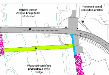
One of the most interesting bits, though, is the detailed plan of the new route. We learn, for example, that the rather worn and tired old swing bridge across the New Cut is to be “refurbished” – it sounds cheaper, after all – with a new footbridge alongside it. The small Butterfly Junction nature reserve is to be flattened and paved over – it isn’t even marked on the maps – and the Bristol Harbour Railway’s stop there is to be replaced by a new one.

The Bristol Harbour Railway is where it gets most silly. The plans finally confirm what was hinted at in the consultation: it is to be turned into a tramway, with buses running on top of it. According to the bid documents:
The tracks for the heritage railway will be retained to provide for seasonal Sunday services and events such as the Harbourside Festival. When these infrequent events occur, services will run on Cumberland Road.
In other words, trains on the Harbour Railway will run on about half as many days as they do now, and along a tramway, which doesn’t quite tally with what my local councillor has told me in the past. As the railway is only just wide enough for one bus, one bus there will be; outbound buses will run along the road all the time, not just on Sundays. To squeeze under Cumberland Road and keep the cycle path, the busway will be narrowed to a single-track road/tramway with traffic lights.
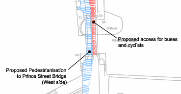
One of the vaguest parts of the consultation documents was: what happens at Prince St Bridge, which isn’t currently strong enough and probably not wide enough to take buses. The consultation map was hard to read; the Evening Post reported that there would be a new bridge. Some people suspected that the current “trial” arrangement of having cars on one side of the bridge and pedestrians on the other was a taste of things to come, ready for the guided bus scheme. Well, it turns out they were right.

Red in that diagram means “bus lane”. Prince St Bridge will be closed to cars; with this scheme, it will be divided between pedestrians on one carriageway, and buses and cyclists on the other. Instead of cyclists being able to run into pedestrians whilst dodging opposing traffic, as now, they’ll be able to get flattened by buses instead. It’s also quite hard to work out how much money has been set aside for Prince St Bridge works, because the costs aren’t itemised very clearly – indeed, the surveyors who reviewed the WEP costings also had trouble on that point.
I don’t think the busway scheme is going to go ahead. That’s partly because the funding bid includes a convenient “low cost alternative” scheme. It is, essentially, the same scheme, same nice new buses, new bus stops, but using the existing park-and-ride route with no new infrastructure. The funding bid says:
A key element of the [Low Cost Alternative] route is the avoidance of the main bridge structures at Ashton Avenue and Prince Street … in order to reduce the construction costs.
The infrastructure will, they say, halve travel times along the park-and-ride route. Whether the Department for Transport think that that will make it worth the money remains to be seen. I’m not convinced they’re going to go for it. In a few months, though, we will all find out.
* as you can see from this Joint Transport Forum presentation released under FOI. Thanks to correspondant Gareth for pointing me to that URL.

 Home
Home