A walk in the park
Some South Wales railway history that is still around, but not for long
Back on to my complex and fragmentary sequence of posts about the history of the complex and fragmentary South Wales railway network. It was prompted by news that Network Rail are working on upgrading the Ebbw Vale line to allow a better train frequency than once per hour, by widening the line from one track to two for a few miles around Aberbeeg. Changing the track, though, involves changing the signalling, and changing the signalling will involve getting rid of a little island of 19th-century mechanical signalling that still exists in Casnewydd/Newport. It’s the signalbox at Park Junction, in the Gaer area of the city.

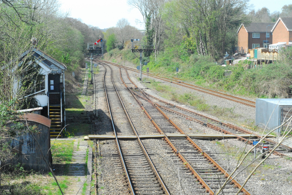
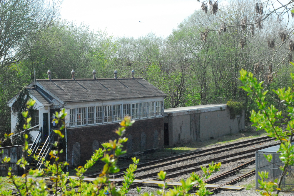
And there it is, with the signals pulled off for an Ebbw Vale train. This picture is from April 2021. It might not look like much from this angle, but if I swing round a bit, you can see that the box is really quite a grand affair for something that only handles a few trains per hour.

You’d be right to assume that, given the size of the building, it was built to control a much bigger junction than the handful of tracks in front of it today.
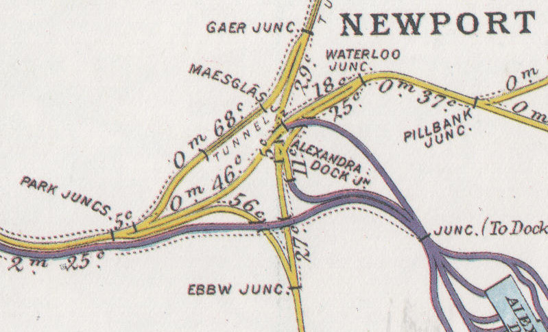
I’ve written before about the Monmouthshire Canal Company building a railway all the way back in 1805, to carry coal and iron down the Sirhowy Valley. This is, indeed, on that 1805 route. When, a few decades later, the South Wales Railway was built from Abertawe/Swansea to Casgwent/Chepstow, it burrowed under the Monmouthshire Canal Company’s railway at right-angles, and a complex mesh of interconnecting routes slowly developed. This is a map from around the time of the First World War, after the MCC and SWR had both been bought out by the Great Western, so confusingly both railways are in the same colour.

The Monmouthshire Canal’s railway runs from left to right, the South Wales Railway from bottom to top, and Park Junction is there on the left. Nowadays, most of the tangle of lines heading towards the docks has gone, and Park Junction is at one corner of a triangle, trains to Cardiff joining the main line at Ebbw Junction and those into Newport joining it at Gaer Junction.
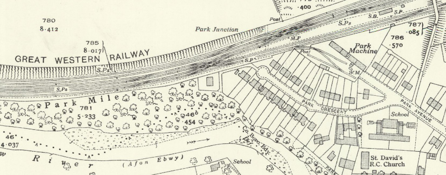
I’ve written previously about that purple line running parallel to the yellow one. That belonged to the company which had extended Newport Docks, the Alexandra (Newport) Dock & Railway Company; and they had built a line from Bassaleg, right alongside the Great Western, so that coal trains coming down the Brecon & Merthyr Railway from Bargoed, Rhymney or Bedwas could reach Newport Docks without paying tolls to the GWR. When they were built, the lines ran around the back of the signalbox, which had nothing at all to do with them. You can see this on a more detailed map from around the same time.

Reproduced with permission of the National Library of Scotland, as was the one below.
I’ve made that one a clickthrough because it’s quite detailed; apologies for the horizontal line, but the original is split across two sheets which I’ve roughly stitched together. Three pairs of tracks in front of the box, belonging to the Great Western; and the pair behind it, separate, spreading out into a bank of sidings. About five years after this was surveyed, the Railways Act 1921 merged Newport Docks into the GWR, and within a few years they had put in additional connections at Park Junction, between the lines in front of the box and those that ran behind it.

Look how much suburbia has grown up in those twenty years, too.
The route through Park Junction lost its passenger services in the early 1960s. Ostensibly this was because British Railways wanted to rearrange the platforms at Newport Station in such a way that there was no space for the Ebbw and Sirhowy Valleys services to turn around; of course, if they had really cared about keeping them, they would have been able to find a way to do it. Back then, there was still heavy freight traffic up and down the valley, from the steel works and the mines; and a large marshalling yard at Rogerstone. Over the following years that traffic dwindled away and shrank, but Park Junction signalbox nevertheless survived, opening a bit less maybe, but still there to signal freight trains up the valley when needed. In the 2000s when the line to Ebbw Vale reopened to passengers, a modern signalling panel was put into one corner of the box to control most of the Ebbw Vale line; but the box still kept its mechanical levers and the tracks past it kept their mechanical semaphore signals, as you can see on the photos above.
Now, in 2022, Park Junction is something of an isolated island given that the main line through Newport is all controlled from the Wales Rail Operating Centre, in Cardiff. When passenger services returned to Ebbw Vale, only one track was kept north of Crosskeys, meaning that the maximum service frequency on the branch is the hour that it takes a train to get from Crosskeys to Ebbw Vale and back down to Crosskeys again. To increase the service means more track; more track means more points and signals; and if you’re putting in more points and signals, it makes sense to move on with the plan to put all of Wales’s signalling into the ROC. So, Park Junction will close, some time over the course of the next few months. It’s a shame, but that’s modernisation for you. I must try to get there again to take more photographs before it goes.

 Home
Home