Pye in the sky (part two)
Some more local railway history
Last week, I posted a little bit about the history of the railway junction at Pye Corner, just outside Casnewydd/Newport. There, the original route of the horse-drawn tramway opened around 1805 is now a quiet, grassy back alleyway, with the railway that replaced it a few yards away. That railway line, now just a single-track branch, strides over the road into Bassaleg with a complex series of three parallel railway bridges, imposing and monolithic.

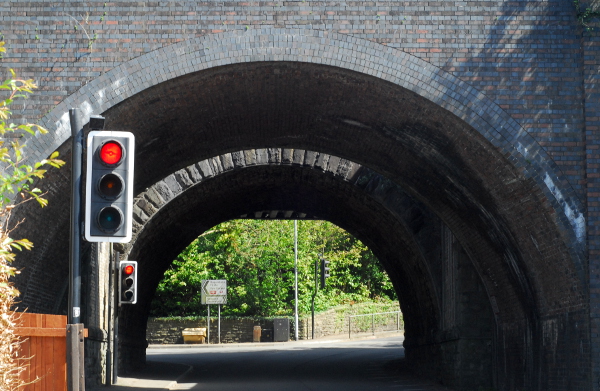
Looking through the tunnel of bridges, you can just about in this picture make out three different ones. In the middle, a stone arch. Beyond it a steel girder bridge and this side of it an arch in blue engineering brick. Three separate phases.
The stone arch is, I presume, the mid-19th-century bridge built by the Monmouthshire Canal Company when the railway line was rerouted from the back alleyway route it formerly took. On the far side: where the bridge was widened by the Great Western Railway, circa 1910 or so, to broaden the line up to Rhisga from two to four tracks. The blue engineering bricks on the nearside? Ostensibly that’s straightforward too—but not as straightforward as I first thought.
I mentioned in the previous post that Pye Corner was a railway junction as early as 1825, when the Rumney Railway was built from Pye Corner up to Rhymney. Now, I’ve said before that the railways of South Wales are complex and confusing, and the Rumney Railway is a case in point. Back in, say, 1860, there were two railways with very similar names, both linking Rhymney to the coast.
The Rumney Railway was the first, built around 1825, and like the Monmouthshire Canal Company’s railway it was horse-drawn, for its first few years. As you might expect from the name, it served Cwm Rhymni, running down from New Tredegar* along the east bank of Afon Rhymni. Unlike most of the valleys of South Wales, Cwm Rhymni doesn’t take a particularly straight line from mountains to sea, and the Rumney Railway followed the river where it takes a sharp eastwards turn at Bedwas and flows through Machen. From there, the river takes a rambling, meandering route through rolling countryside, past Ruperra Castle and down to the sea just east of Caerdydd/Cardiff. The railway, on the other hand, cut across the narrow neck of land separating Afon Rhymni from Afon Ebwy, to reach the latter at Rhiwderin, and ending by joining the Monmouthshire Canal Company’s railway about a mile further on. How it crossed the Afon Ebwy to get there will be the subject of a later installment.
The confusion arises from the Rhymney Railway, which came along in the 1850s partly because the Rumney Railway (also sometimes known as the “Old Rumney”) was by the time it turned 30 already something of a wheezing, antiquated and outdated little line, upgraded to steam but still using horse-era track. The Rhymney Railway was built to give Cwm Rhymni a proper, modern railway, and it doesn’t really concern us here save to say that it didn’t stick with the river as the Rumney Railway did: it headed into Caerffili town centre, then burrowed southwards through the hills into Caerdydd with a tunnel over a mile long. The Rumney Railway’s owners were worried they were getting left behind but didn’t have the money to upgrade their line; within five years of the Rhymney Railway opening, they had sold the older line to the Brecon & Merthyr Railway, so that the latter railway could use it as a stepping-stone to reach the sea. They did have the money in the bank to rebuild the Rumney Railway in a modern fashion, and did so, building further connections from Machen to Caerffili.
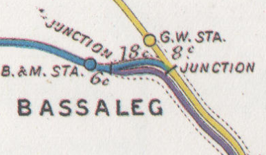
This doesn’t explain where that brick-built bridge comes from, though. Here’s a map of the railway connections around Pye Corner circa 1914. This is from the Railway Clearing House junction diagrams, which were made to give definitive plans of where railways interconnected and what the distances between junctions were, in order to be able to work out per-mile traffic rates.

Yellow is the Great Western Railway (the former canal company line), blue is the Brecon & Merthyr, and you can see both companies have their Bassaleg stations. What’s the purple line though? That belonged to the company which owned the local docks, the grandly-named Alexandra (Newport & South Wales) Docks & Railway, or AND&R to its friends. They had wanted the collieries of Cwm Rhymni to be able to get their coal to the docks of Casnewydd, without having to pay any additional charges to the Great Western Railway; so they built a line parallel to the Great Western’s tracks between Pye Corner and Mendalgief, enabling coal trains to come straight off the Brecon & Merthyr and onto the dock company’s own line of route without touching the Great Western.
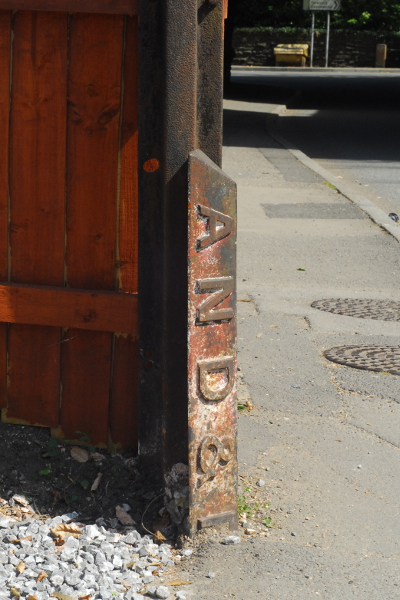
So that’s who built that imposing blue-brick bridge? Well, maybe. There’s certainly a boundary post still in the ground nearby, marking this off as AND&R land.

That answers the question, surely? Well, maybe not. We haven’t really looked at all of the evidence yet. However, as this post is already getting rather long, the conclusion (insofar as there is one) is sadly going to have to wait for another day.
* I’m not entirely sure where its original top terminus is. The Rumney Railway is particularly poorly-documented, so I’m not sure anyone is entirely sure quite where its original top terminus was.

 Home
Home