The Return of the Guided Bus
In which we wonder how the Misguided Bus will fit along Winterstoke Road
Time to return to the West Of England Partnership’s misguided Bristol Guided Bus project,* I think, although Councillor Bradshaw never did reply to my last email. The rude chap. In the meantime, I’ve been poking my nose around the Winterstoke Road area.
Whilst I was doing so, the Evening Post, as I’d done, interpreted the scheme’s maps to read that a new bridge was going to be built over the harbour. It apparently isn’t, although you have to look at the maps very very carefully to spot this. Which is a sign of how poor this whole “consultation exercise” is, if the main local press outlet is allowed to get the wrong impression like that. In the same story, the partnership admitted that they have only a vague idea of the cost of the scheme. And then, Cumberland Road was closed for emergency repairs, due to a burst water main. At present the road’s mostly used by cars, with relatively few buses. What’s going to happen to it when there are buses putting much, much more stress on it every few minutes?** Moreover, this, like any other traffic incident on either Cumberland Road or Coronation Road,*** froze the rush-hour traffic trying to get south out of the city centre. What’s going to happen when the westbound side of Cumberland Road is taken up by bus lane?
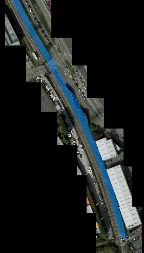
Anyway, pressing on. Winterstoke Road, where the new bus road is due to run alongside the railway to Portbury. This railway line was only used occasionally for the best part of thirty years, before being rebuilt for heavy coal traffic from the docks. When that happened, it was singled, so there’s plenty of space alongside the line. Plenty of space for a new road, you might think. Let’s look.

Not much room there at all, really. That blue band is the width of two guided busways, with a narrow kerb at the side for access and evacuation. I’ve drawn it right up to the edge of the still-active railway; and it takes up, well, pretty much all the space available. No room at all for the promised cycleways alongside the road. I’ve widened it a bit at the site of the Ashton Gate stop shown on the maps;**** if it’s any bigger than I’ve drawn, it then starts to swallow up the existing (and rather poor-quality) cycle/footpath too.
What’s going to happen to that building alongside the line? The partnership’s simulation video shows it on the ground and unaffected by the busway – which, at the bottom of that picture, is due to ramp up onto a flyover and, at the top, execute a sharp turn across the railway and off to the left. Is there really enough room for that, though? Without scraping the side of the building every time a bus passes? I’m not very convinced.
* You know, the one they like to call “Bus Rapid Transit”, or just “Rapid Transit”, to gloss over the fact that it’s nothing more than a slightly-altered bus route.
** Some useful information here: the stress caused on a road varies with the fourth power of the axle loading, more or less. In non-maths language: if you double the weight on a wheel, that wheel will cause 16 times as much damage to the road. A car’s axle loading isn’t likely to be above 1.5 tonnes even for something big; a bus will be more like 9 or 10 tonnes on its heaviest axle. That six-times weight multiple turns into a 1296-times damage multiple. So, a stream of cars with one passing every couple of seconds – supposedly the safe separation, according to the Highway Code – causes roughly the same amount of road damage as one or two buses per hour. That’s a very rough back-of-envelope calculation, but gives you an idea of the scale of difference we’re talking about. Trucks, of course, are even worse.
*** such as the fatal motorbike accident at the Coronation Road/Dean Lane junction a few weeks ago.
**** using the size of the Leeds guided busway stops as a guideline

 Home
Home